

The Department of Transport, Tourism and Sport has been advised that a geotechnical survey will be undertaken in the Irish Sea (off the Wicklow coast) to provide site investigation information to facilitate the development of the Arklow Bank Wind Park.
Weather depending, survey work is anticipated to start in either late August or early September 2020 and be completed by the end of November 2020.
The location of the surveys will be off the Wicklow coastline, within an area as shown at Appendix 1 below.
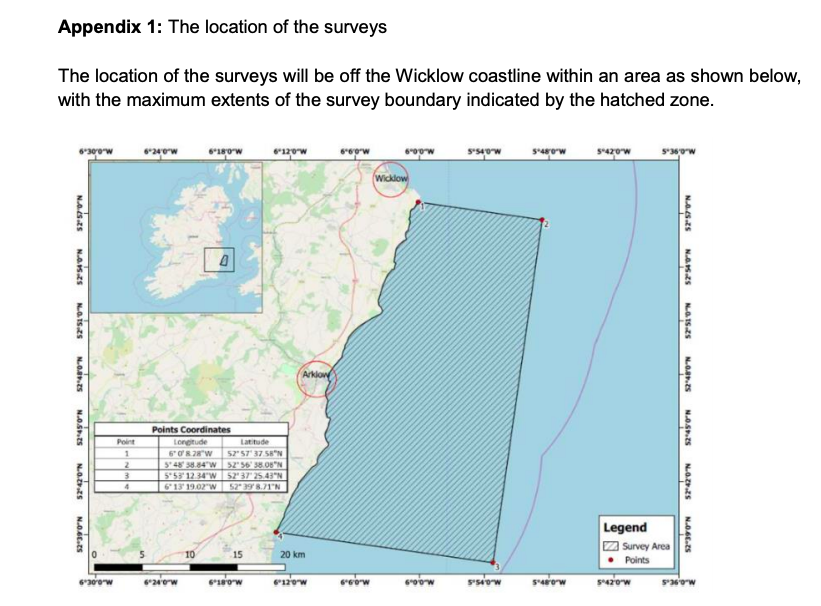
The survey activities will include approximately 15 boreholes which will be drilled at discrete locations within the hatched area.
The geotechnical survey work will be completed by the Contractor Geoquip using the vessel, the “GEOQUIP SAENTIS” (Callsign: C6UM8).
This vessel is an 80 meter long dynamically positioned specialist survey vessel, with her current draught reported to be 5.1 meters and beam of 20 meters.
As this vessel will be engaged in site investigation survey operations, it will be restricted in its ability to manoeuvre. Vessels are requested to leave a wide berth.
The vessel will be operating 24 hours per day during survey works.
For further information with respect to the survey operations, please contact: Paul Doherty, Survey Manager at SSE at paul.doherty@sse.com
All mariners are reminded of their responsibilities under the International Collision Regulations and are reminded of Marine Notice No. 17 of 2007, which gives general advice in relation to the activities of vessels engaged in survey work for hydrographic, seismic, fishing research and underwater operations.
The International Regulations for Prevention of Collisions at Sea (COLREGS) are implemented in Irish law by the Merchant Shipping (Collision Regulations) (Ships and Water Craft on the Water) Order 2012 [S.I. No. 507 of 2012], and the Signals of Distress (Ships) Rules 2012 [S.I. No.170 of 2012]. See Marine Notice No. 06 of 2013.
The full notice can be found here

Recent Comments